Rex comes up with the greatest schemes. In his latest, he found a good reason to drive California State Route 1: we needed a spotting scope.
Route 1, the famous coastal road from that runs from Mendocino County to Orange County, does not accommodate 30-foot trailers. When we came south from Crescent City, we took the faster, straighter US 101. But the incomparable Route 1 calls. So when two different birding couples mentioned Out of This World in Mendocino as a great source for spotting scopes, Rex's wheels started turning. He has shopped the powerful optic aids for weeks, and sure enough, when we called, James the helpful clerk told us that he did have a Nikon ED50 in stock--just what we have been wanting. Preordained, right?
So on Tuesday, we headed north then northwest, driving over the hills on a very crooked road toward Boonville and on to Mendocino. Once we accomplished our business, we took a too-short tour of the town and ate our lunch overlooking the ocean then followed the coast south.
Here's a link to the route we followed, and a few photos are posted here. The entire 200-mile journey took 13 hours. We don't need to ever drive that road again, but I am so very glad we did. Enjoy the slideshow!
Friday, August 30, 2013
Sunday, August 25, 2013
Plan B
UPDATE: As we expected, the National Park Service has now closed indefinitely Hodgdon Meadows Campground, where we were to stay through September 3rd. According to the NPS, most of park remains open and smoke-free. Rex and I have decided to go to the south side of Yosemite on Thursday, in hopes of finding a spot in a "first-come, first served" campground.
What do we do when the 15th largest wildfire in California history closes the Yosemite campground we reserved four months ago? We go to Plan B: bikes, birds, and beer.
After reuniting in San Francisco last Saturday and retrieving our fifth wheel, the TI, from storage on Sunday, we intended to regroup in Santa Rosa for a few days before heading east toward Yosemite, where a campsite had our name on it, starting August 22nd.
But Santa Rosa is a very comfortable town--maybe not as easy as Austin, which I've heard Alejandro Escovedo aptly call the Velvet Rut. Still, the weather here is almost perfect, the streets are easy to navigate with car or bike, and the produce at the even the big-box stores is incredibly fresh, flavorful, and cheap.
Then there's the beer. Russian River is in Santa Rosa, Bear Republic in Healdsburg, and Lagunitas in Petaluma--three breweries with long-standing and well-deserved national reputations within 30 miles of each other.
By Thursday, we found ourselves still in Santa Rosa, and that was a good thing. Otherwise, we would have been halfway to Yosemite when we learned that our campground was closing due to the Rim Fire.
In our version of lemons-to-lemonade, we biked through wine country on Friday. I've mapped out our 25-mile loop here. Most of it was low- or slow traffic, but some sections were too dangerous for bicyclists, no matter what the Sonoma Cycling Club says. We would do it again but incorporate more of Dry Creek Road into our route--and more wineries. We only made it to one thought there were at least three dozen offering tastings on our loop.
Late Friday night after our ride, curiosity got the best of me and I went looking online for the local Audubon chapter. Sure enough, one of the premiere birding sites in the country--Bodega Bay--is only 25 miles away. And wouldn't you know it, but the Madrone Audubon Society would be hosting a guided walk there on Saturday at 7:30 am. We were out the door by 6:35 the next morning and had an absolutely amazing day: 17 life-list bird and 48 species sighted in total.
On our return trip from Bodega Bay, we made two stops in Sebastopol: the Luther Burbank Experiment Farm and a month-old brewery and restaurant called Woodfour Brewing Company.

We still don't know when we will leave Santa Rosa, But we will make the best of it, I am certain of that.
What do we do when the 15th largest wildfire in California history closes the Yosemite campground we reserved four months ago? We go to Plan B: bikes, birds, and beer.
After reuniting in San Francisco last Saturday and retrieving our fifth wheel, the TI, from storage on Sunday, we intended to regroup in Santa Rosa for a few days before heading east toward Yosemite, where a campsite had our name on it, starting August 22nd.
But Santa Rosa is a very comfortable town--maybe not as easy as Austin, which I've heard Alejandro Escovedo aptly call the Velvet Rut. Still, the weather here is almost perfect, the streets are easy to navigate with car or bike, and the produce at the even the big-box stores is incredibly fresh, flavorful, and cheap.
Then there's the beer. Russian River is in Santa Rosa, Bear Republic in Healdsburg, and Lagunitas in Petaluma--three breweries with long-standing and well-deserved national reputations within 30 miles of each other.
 |
| Lagunitas employees really love their jobs. In Petaluma, CA. |
In our version of lemons-to-lemonade, we biked through wine country on Friday. I've mapped out our 25-mile loop here. Most of it was low- or slow traffic, but some sections were too dangerous for bicyclists, no matter what the Sonoma Cycling Club says. We would do it again but incorporate more of Dry Creek Road into our route--and more wineries. We only made it to one thought there were at least three dozen offering tastings on our loop.
 |
| Vineyard on West Dry Creek Road near Yoakim Bridge Road |
 |
| Another vineyard, same general location |
 |
| Harvest time? |
 |
| Rex re-hydrating, Russian River valley south of Geyserville |
 |
| Bodega Head; here we saw pelagic cormorants, Brandt's cormorants, wandering tattlers, and a common murre, to name a few. Many, many thanks to Gordon Beebe and all the Audubon regulars for patiently sharing so many magical birds with us. |

Did you ever think about the origins of Shasta Daisy? Me neither--until I visited Luther Burbank's farm and learned that the horticulturalist created this white-and-yellow favorite. I assumed the Shasta Daisy had been with us since God formed dry land, but Burbank introduced it in 1901. It is one of more than 800 new plants that he produced in his life time, including the first commercially grown cherry and dozens of other improved flowers, nuts, fruits, and vegetables. A worthy legacy, if you ask me.
 |
Rex inspects some of Luther Burbank's work: an experimental chestnut.
|
 |
| A Berliner weisse at Woodfour Brewing Company. Skip it and go for the Belgium dubbel instead. |
Monday, August 19, 2013
When in Austin...
As you probably know, dear reader, I spent most of last week
in Austin, Texas, defending (successfully!) my dissertation. I have almost no photos to post, but even so, this is a good opportunity to promote some of my favorite Austin haunts.
Central Market:
Perhaps it is lame to think of a grocery store as a destination, but nevertheless,
this a great place. Whole Foods still out-wows Central Market, but I have never
gone to Whole Foods to truly shop. In comparison, I went to Central Market
twice in five days last week.
Mi Madres: I
probably would not treasure this place, or even know about it, if it wasn’t in
my old neighborhood. Still, I know many
people who have never lived nearby who also swear by Mi Madres’ Tex-Mex—particular
for breakfast and brunch. The food is consistently good and the prices are very
reasonable. Most importantly, it feels just like a neighborhood place should: comfy,
friendly, no pretension. Rex and I found Mi Madres on our first trip to Austin.
We were particularly impressed when we learned that the owners lived in the
neighborhood; that sold us on the East Side.
Franklin BBQ: Obviously,
Franklin needs no promotion, but I do want to take moment to write about the
line. Yes, waiting for Franklin BBQ, which takes a minimum of three hours during
the summer months, is a big investment. But approached with the right attitude,
standing in line with fellow smoked-meat devotees can be very rewarding. Everyone
has a story, and one will hear lots of very interesting ones on any given
morning while in the Franklin cue. Plus, food just tastes better when one has worked
for it. And remember--that’s why the line is so long: It takes a great amount
of time and effort to slow-smoke meat over an open fire. If it could be
produced on an assembly line, you could get it at Rudy’s, and then you wouldn’t
want it.
Black Star Co-op: When
we first moved to Austin, Rex and I went to several of Black Star’s promotional
events where they served great homebrews, sold shares, and explained the
concept of a cooperative brew pub. I didn’t get it. Brewing craft beer is an
art—why would anyone want to do it by
committee?
It wasn’t until Black Star opened that I grasped the value
of a co-op. (Which is funny, because I’m a farm kid, who should have known
about co-ops. Why I didn’t associate them with owner-operator values is another
story.) Anyhow, after Rex and I first went there, I quickly realized that the
co-op was less about finding the best way to brew beer and more about finding
the best, most ethical way to do business. Black Star employees are paid a
living wage and no tipping is allowed. Fairness and transparency in how service
workers are compensated? What a concept! More to the point, Black Star’s food
menu is creative, high-quality, and local—an interesting take on pub grub. The
regular rotation of Black Star brews is also distinctive and of high-quality.
On my latest trip, I was lucky enough to indulge in their version of the Berliner
Weisse, which they call the Waterloo. It’s a summer seasonal made with peaches,
wonderfully tart and refreshing—one of my favorite beers of all time. Not a popular style, only a
few beer nerds appreciate Berliner Weisse, so the brewer took
a risk when he came up with this one. But obviously, the board supported the brewer in what might have been a
commercial disaster. Long story short: If
a restaurant can be run based on democratic decision making and shared profits,
any business can.
 |
| A big, little beer (Avery's Maharaja); a regular-sized beer with average ABV (Black Star's Elba), and a very small, big beer (Black Star's Waterloo). |
I’m running out of steam now, but another Austin-centric
business worth patronizing, in my humble opinion, is Salt and Time. I had some of Ben’s
excellent bacon on my last trip. It reminded me of the bacon that came from our
hogs, killed and processed in Petersburg, when I was a kid.
Sunday, August 18, 2013
Lost Coast
In spite of our title, this tale has nothing to do with the Lost Coast of California, a section of relatively remote and very undeveloped coastline that runs from Rockport to Ferndale. Because of geo-technical challenges, the state never developed roads through this part of the state. Add in depopulation during the Great Depression, and you have a rare section of lovely and lonely seashore.


But that's not what this post is about. We actually were several miles north of the Lost Coast on August 8th when we got lost on the coast. In fact, because some sea lions distracted us, what could have been
an 11.6 mile walk to the beach and back turned into something closer to 14 miles. Even so, it eventually became an amazing day of hiking--probably in our top 10, if we kept track of such things.
First, our early start got delayed by an hour, as we needed fuel for the truck (oops). After a short detour to Klamath to get diesel at a station run by the Yurok tribe, we drove the Newton B. Drury Scenic Highway to the visitors' center of the Prairie Creek Redwoods State Park. When we arrived at about 8:30 a.m., a small herd of Roosevelt Elk, all males, were waiting.
First, our early start got delayed by an hour, as we needed fuel for the truck (oops). After a short detour to Klamath to get diesel at a station run by the Yurok tribe, we drove the Newton B. Drury Scenic Highway to the visitors' center of the Prairie Creek Redwoods State Park. When we arrived at about 8:30 a.m., a small herd of Roosevelt Elk, all males, were waiting.
 |
| Elk hanging around the park employee quarters |
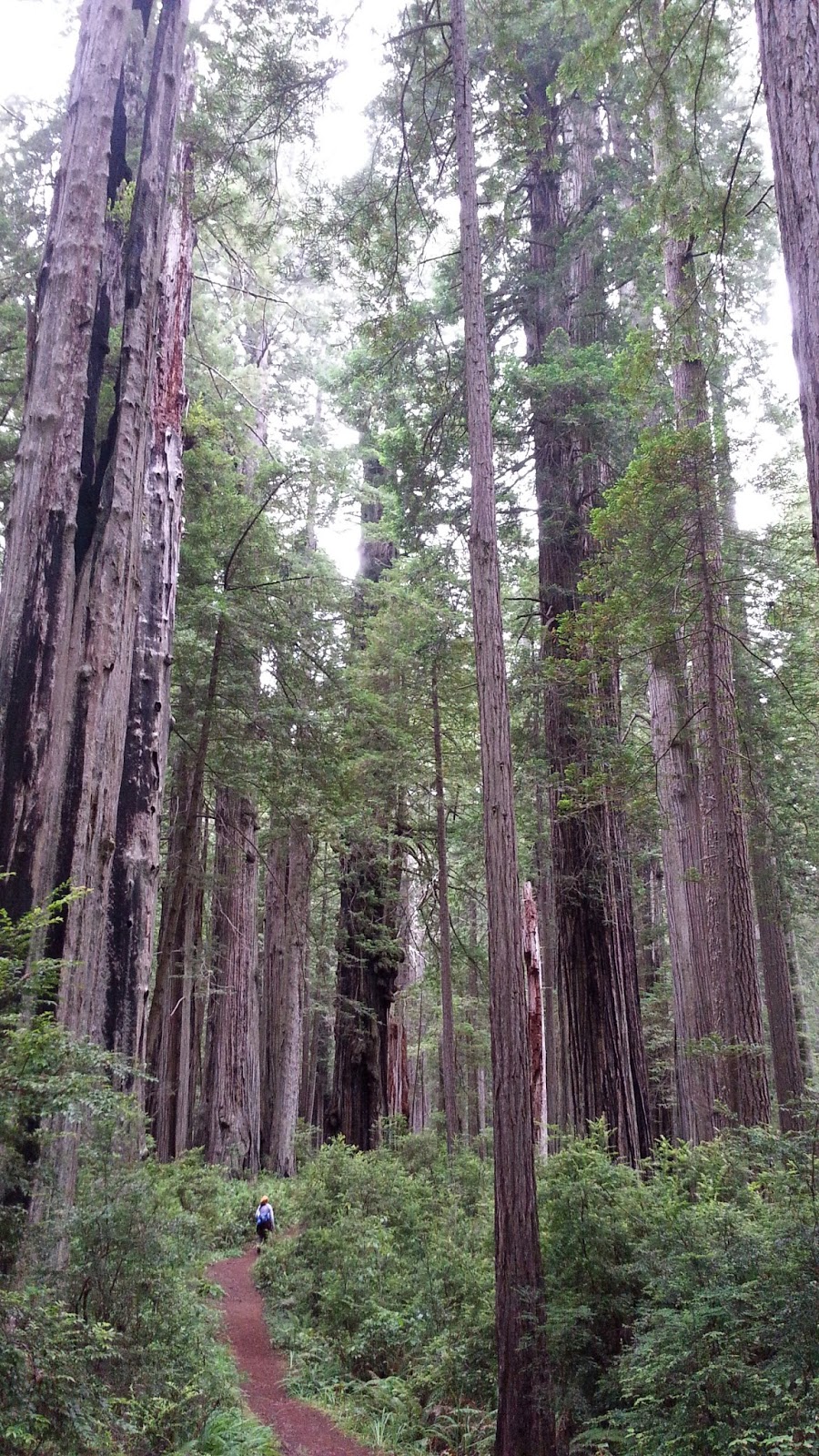 |
| Miners Ridge Trail |
We started on the Miner’s Ridge Trail, headed for the Gold Bluffs Beach
campgrounds. The whole point of this hike was to walk a long loop through old-growth coastal redwoods. Prairie Creek is known for a group of trees called the Atlas Grove. The grove contains the Iluvatar a tree, which is 320 feet tall and 20.5 feet in diameter at breast height. However, the location of this grove is undisclosed to the public to protect it. But there are plenty of big trees along the main, publicized trails.
We walked the Miner's Ridge trail from the visitors' center to the ocean under heavy fog that sometimes became mist. This added to the mysterious, other-worldly feel of the 300-foot redwoods. We heard many birds but could identify only one--a varied thrush.
Once we made it to the beach, we headed north and got distracted by a group of double-breasted cormorants, brown pelicans, and ring billed gulls. As we kept going, we noticed a group of seals was also feasting on what must have been a mother lode of fish. Every time a cormorant would dive and resurface, it would have a fish. After watching this feeding frenzy we kept walking the beach, not realizing that we had missed our turn back inland.
We eventually realized our mistake and came south to Fern
Canyon. The walls of this canyon were up to 50 feet straight up and covered with up
to 5 different ferns, giving the ravine a very airy feel that can't be captured on film--not on our cameras, anyway.
The extra miles on the beach zapped our energy, so we took a lunch break before heading back up the James Irvine trail to the visitors center. In addition to coastal redwoods, many large Douglas fir, sitka spruce, and western hemlock populate the park.
We walked the Miner's Ridge trail from the visitors' center to the ocean under heavy fog that sometimes became mist. This added to the mysterious, other-worldly feel of the 300-foot redwoods. We heard many birds but could identify only one--a varied thrush.
Once we made it to the beach, we headed north and got distracted by a group of double-breasted cormorants, brown pelicans, and ring billed gulls. As we kept going, we noticed a group of seals was also feasting on what must have been a mother lode of fish. Every time a cormorant would dive and resurface, it would have a fish. After watching this feeding frenzy we kept walking the beach, not realizing that we had missed our turn back inland.
 |
| Gold Bluffs beach trail |
 |
| Fern Canyon |
The extra miles on the beach zapped our energy, so we took a lunch break before heading back up the James Irvine trail to the visitors center. In addition to coastal redwoods, many large Douglas fir, sitka spruce, and western hemlock populate the park.
 |
| New plants growing on a fallen redwood (nurse tree) |
Wednesday, August 14, 2013
Why are we whispering?
 |
| A walk in the woods... Stout Memorial Grove |
 |
| Colene at the Boy Scout Tree |
We found ourselves whispering to each other as we went through
the forest. Call us crazy, but it just seemed right to be reverential. Maybe
it’s because some of these trees are more than 2,000 years old. Perhaps we were
cowed by their size: 300 feet high, and some appearing to be more than 20 feet
in diameter.
Whatever the reason, we were glad we got out before the
crowds so that we could enjoy some quiet time among the trees.
 |
| Man among giants |
This isn’t just a tree or two. The State of California, in
conjunction with the National Park Service, has protected more than 100,000 acres
of redwood forest. That doesn’t mean that redwoods are out of the woods (ha
ha), as erosion from upstream logging, farming and development can negatively
impact the redwoods nearer the coast.
 |
| Colene admires her surroundings |
We are very grateful that some forward thinking folks like
Mrs. Stout were motivated to help save these forests for future generations to
see and admire. As the photos don’t begin to do them justice here is a quote from John Masefield "They are not like trees, they are like spirits. The glens in
which they grow are not like places, they are like haunts—haunts of the
centaurs or of the gods."
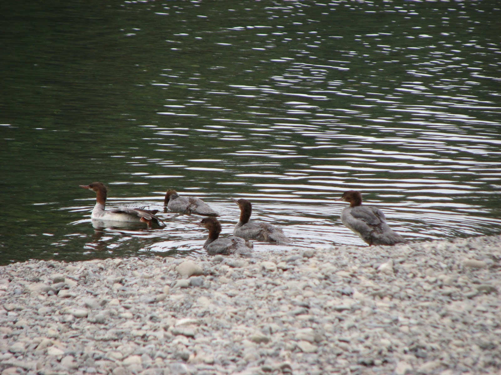 |
| Mergansers on Smith River |
 |
| Rex finds a seat |
 |
| So peaceful |
Monday, August 5, 2013
Only a Fool... Mount Brown
 |
| The lookout is on the mountain behind the Red Bus |
 |
| The lookout is now visible |
 |
| Looking towards the southeast |
 |
| The clouds hung in this valley all morning |
 |
| I could see Granite Chalet in the binoculars |
 |
| You can see all of Lake McDonald from here |
Sunday, August 4, 2013
Tips for Travelers to Glacier National Park
Dumb luck makes for happy traveling, but the if-we-had-only-knowns of road life cannot be avoided entirely. Guidebooks are helpful, but they rarely cover the
mundane details, like where to buy milk or which road has the fewest potholes. To fill the gap and help anyone planning a trip
to the places he have been, I am compiling a list of tips for each park. Think of it as
learning from our happy discoveries and mistakes.
Getting There
If you are driving up from Missoula, go around Flathead Lake
on the east side, not the west. The
road to the east travels along fewer subdivisions and better scenery. It’s also
fewer miles and less traffic.
If you are driving to Many Glacier from the west side of the
park, US Hwy 2 is a good, fast road. Do not take either state road 49 or US Hwy
89 from East Glacier Park village to Many Glacier—unless you want a long slow,
ride. If you are towing anything at all, take Hwy 2 to Browning, then north and
west on state road 464. Not only is it a good road, but the prairie vistas it
navigates are worth seeing.
Where to Stay
There are good reasons for all park visitors but especially
hikers to use an east-side base. The west is more congested and the most
popular day hikes are more easily accessed on the east side. If you can get
into Many Glacier campground, stay as long as you can—it is an idyllic setting
with easy access to lots of good ranger talks and hikes. Two Medicine is short
on people but has plenty of scenery, good hikes, or other fun things to do.
Choose this spot if you need a little elbow room and quiet to fully enjoy
nature.
Supplies
There is no diesel in West or East Glacier or Babb. There is
a station selling diesel just outside the St. Mary’s entrance. There is also
diesel in the town of Browning. On the west side of the park, better fill up
with ruby red in Hungry Horse.
The best grocery store we found was Canyon Foods in Hungry
Horse. The supermarket (as well as the gas station and outfitter) just outside
the St. Mary’s entrance is run by a park concessionaire. They charge only
slight inflated prices for fuel, which is to be expected, but they offer just the barest of essentials in their grocery and Cheerios are $9 a box. The stores
in East and West Glacier are somewhat better. Babb also has a respectable
general store, but overall, stock up before you get to the park.
If possible, make it a point to be in Babb at 5 p.m. on a
Wednesday. At that hour, a group of Hutterites parks in front of the general
store with a truck full of the freshest, most
beautiful regional fruits and veggies, as well as baked and canned goods, all
at ridiculously low prices. It is hard to find quality fresh produce—let alone
local products—when traveling around the national parks, so this a godsend. I
was only there once, so a call to the Babb post office to confirm would be
wise.
What to Do
No matter what, walk a little. The hiking is
absolutely the best in Glacier. If a visitor never sets foot on a trail, she
misses the best that the park has to offer. Just go as far up the trail as you
can—you can always turn around. The experience is completely different when
walking as compared to standing at a scenic overlook.
Almost everyone can and should walk the 1.5 miles to Hidden
Lake from Logan Pass, totaling 3 miles of hiking. It is a boardwalk, meaning
the footing is smooth and sure. There are some challenging steps, but at a slow
pace and with a friend’s hand, it can be done by a toddler or an 90-year-old.
If you’re a long-distance hiker who avoids “nature trails,” you are cheating
yourself if you miss this one. But get out on the trail early—no later than 8
a.m. It’s total pandemonium thereafter.
 |
| Coming down from Hidden Lake |
We were mostly impressed with Glacier Boat Company, which
runs boat tours and canoe/kayak rentals on all park lakes. The young people
that work for this family owned company seem to really like their jobs. Two
Medicine and Swiftcurrent Lakes are excellent flat-water options for canoeing
(assuming the wind is in check) and the boat tours are fun and
informative.
 |
| Picnic at Two Medicine Lake |
A word about using the boat tours as a way to shorten day
hikes: Be warned that the return trip requires one to be very patient or very
aggressive, as there is always a crush of hikers waiting to return and no
orderly process for determining who gets on the next boat and who gets left
behind. If I had it to do over again, I would buy a one-way ticket, taking the
boat to the top of the lake at the beginning of the hike, but walking myself
back all the way to the trail head at the end of the day. There’s nothing more
disappointing after a mind-blowing day in the most amazing of God’s creation
than to be smacked back into reality by mob rule at the bottom of the hill.
Bikers, Logan Pass is popular, and I am surprised at the
number of people who make the climb in spite of the traffic, which, admittedly, moves slowly. It’s terribly inspiring to watch bikers come up the
pass, and if you have any inkling at all, do it! Also, check out Chief Mountain
Road to the Piegan Port of Entry and on to Waterton Lakes. The shoulder on
this road is narrow, but the speed limit is 45 mph or less on the U.S. side and
50 kph in Canada. The route affords wonderful views, includes many roomy pullouts,
and offers fun curves as well as challenging up-and-downs. Take your passport
and watch for free-range cattle on the U.S. side.
Waterton Lakes, the Canadian national park opposite of
Glacier, is certainly worth your time, even if just for the day. Walk inside
the Prince of Wales Hotel, stroll the walking and biking trails around the
lake, and check out the shops at the town site. Allow 45 minutes to cross the
border each way, although it only took us only 30 when crossing back into the
U.S. during mid-afternoon.
 |
| Waterton Lake and Prince of Wales Hotel |
Places to Camp
The season is short and the demand is high, so be prepared
for price shock. One-room cabins with no plumbing go for a minimum of $80 per
night, $120 if your want running water and a bathroom. The KOAs get $43 for a
tent site, plus tax. Because the park abuts national forests on the west and
south, you can find free spots off Hwy 2 but only for cars and small vans, and there
is a lot of private land mixed in, so watch for “no trespassing” signs. There
are also two forest-service campgrounds on the southeast side of the national
park off Hwy 2. They ask $15 per night.
For RVers, our best finds were YR RV Park in East Glacier
and Blackfoot Outfitters four miles north of Babb. Both are very reasonably priced ($25 and $35
for full hookups, respectively), and their utilities work well. These are
no-frills spots, mind you, but if you don’t want to pay for hot tub, pool,
on-site restaurant, etc., these are your places. Both have lovely views. YR has a clean laundry mat on site. Roz, the owner, lives in the big house on the
property. Alger, the owner/operator of
Blackfeet Outfitters, also lives on site, but he often guides hunting and
fishing trips during the day. If no one is around at either place, just park
and settle up later. There are also two cabins on Alger’s property, but they
seem to be popular, so you should call ahead for those if possible. And don’t
be intimated by Alger’s close proximity to the highway—there is no traffic once
the border closes. Both YR and Blackfeet are very peaceful, quiet places.
 |
| Sunlit view of mountains, from Blackfeet Outfitters near Babb, MT |
Posher Accommodations
There's no shame in staying at one of the classic lodges! Based on our lobby tours of all of the Glacier hotels, East Glacier Hotel must the best. Whether or not you book a room, go have it look. It's worth it, and lots of people do. It's also a good way to learn about the (white) history of the park, as the hotels offer tours and very informative lobby displays.
 |
| Front Lawn at East Glacier Hotel; Amtrak station in the distance |
 |
| Lobby at the East Glacier lodge |
Communications
Montana seems to be ahead of the curve in cellular
technology; we accessed 4G almost everywhere. There is, however, no cell-phone signal
along Hwy 2 between West and East Glacier.
Hiking the hard way

This couple, plus one study group from the Glacier Institute, were the only other people who walked up this trail, although Mark and Jan have
counted more than 300 people coming down the trail in a single day. You see, most
people walk the basically level section of the Highline Trail from Logan Pass
to the Granite Chalet, then down the steep four miles to the Loop.
I initially planned to walk up and back down the same four
miles, skipping the very busy Highline Trail. But everyone I met said the walk on
the Highline would be worth it. It was another 8 miles out—four more than I had
planned—but the views were especially good looking into Logan Pass. I hope you
agree.
 |
| Logan's Pass in the background with Going To the Sun Road climbing the mountain side |
 |
| Stunning view from Granite Chalet |
 |
| Looking back at towards Haystack Pass |
 |
| The Highline Trails hugs the mountain |
 |
| In the distant valley you will notice McDonald Lake |
 |
| Rex with 8987 Ft Heavens Peak in the background |
 |
| The Garden Wall |
Saturday, August 3, 2013
Endangered Species
Thursday, Rex and I left Glacier National Park after
spending two weeks camped near its borders. We've planned several posts about
our experiences in and around this park; I will begin with some thoughts about
our last trek: Grinnell Glacier.
The Grinnell Glacier hike comes advertised as one of the
best in the park. As our photos attest, the trail lives up to its billing. But the
hike’s popularity is also its downfall: many, many, many people hike this trail. But if you are in the right frame of
mind, sharing the way can be a happy part of the experience. We met several
interesting people, including Vic the microelectronics engineer as well as pastors
Robin and Janet.
 |
| Mount Gould (highest point, center) from the top of Lake Josephine; Salamander Glacier is on the right |
But the true bittersweet of the Grinnell Glacier hike is its
namesake. Like all glaciers in the park, Grinnell will soon be gone, probably by 2030 if not sooner. In 1850, there were
more than 250 glaciers in the immediate vicinity. There are now 25, and
they are only poor shadows of their former selves. Compare, for example, this 1910 photo of
Grinnell Glacier with mine below.
 |
| Early view of Grinnell Glacier from the trail |
As most hikers do, apparently, we took the tour boat to the
top of Lake Josephine, eliminating the first and last two miles of walking.* The
hike quickly leaves the lake via several steep switchbacks then relaxes into a
more reasonable grade, affording clear views up and down the valley for the
trail’s entire length. Grinnell Lake looks particularly striking with its
blue-green hue, made so by sunlight refracting through microscopic particles of
glacial
flour—which is rock pulverized by the glacier then washed into the lake**
 |
| Lake Josephine (left) and Grinnell Lake (right) |
 |
| Grinnell Glacier below Mount Gould |
 |
| Panorama of Grinnell Glacier and its melt pond |
To make any meaningful difference as individuals, we can adjust those daily activities that make the greatest contributions to
carbon output. These activities include:
- how we get to work;
- how we heat and cool our homes; and
- how we get our food.
Anything that decreases the amount of fossil fuels we consume to do these the things will also reduce our personal carbon footprint. But changing
our system requires concreted public efforts, both national and global. Until
the United States gets serious, international agreements such as Copenhagen Accords will be impotent. And the United States will not get serious until
enough citizens speak out.
To end on a happier note, the bird highlight of the
hike was an American dipper—only the second one I have ever seen.
*I regret this choice. If you
plan to do this hike, please also see my thoughts under a later post, “Glacier
National Park Tips.”
**This I learned from the
very knowledgeable park ranger who led a group to the glacier.
Subscribe to:
Posts (Atom)